Site Plan Control is an important means of encouraging well-designed functional and accessible development. This involves the City and commenting agencies reviewing plans that show the location, design and massing of buildings, the relationship to adjacent streets and buildings, public access areas, the layout of parking and service areas, site landscaping and other aspects of the development.
Where areas of the City and development are subject to Site Plan Control, Council or delegated staff may approve the plans and drawings, and the owner may be required to enter into an agreement to secure the construction of the project as shown in the plans.
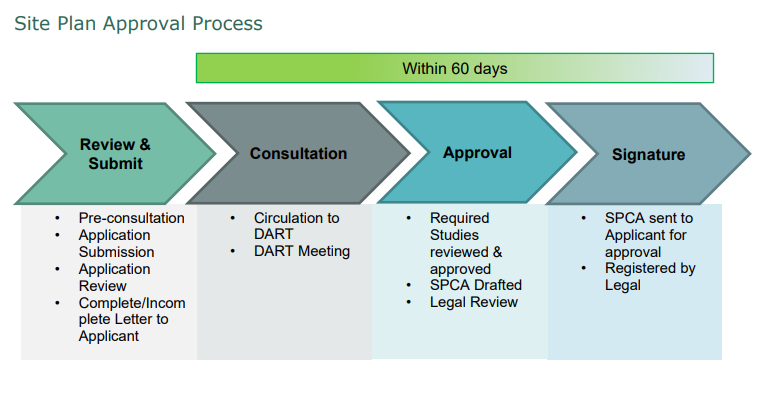
A member of the Planning Services Department reviews the application to ensure that all supporting information and required fees have been submitted and that the application is complete. All development applications are processed through the City's Development Application Review Team (DART).
Check out the City's Development Handbook for details on the Site Plan Control Agreement Process
A member of the Planning Services Department reviews the application to ensure that all supporting information and required fees have been submitted and that the application is complete. All development applications are processed through the City's Development Application Review Team (DART). Details on the submission requirements are contained within the Site Plan Control Agreement Application form and in the City's Development Handbook.
Two (2) copies of the Site Plan showing the proposed development and two (2) copies of a plan showing Existing Site Conditions, folded, to legal size or smaller, are required. A more complex development is required to be twenty-four (24) inches by thirty-six (36) inches in size.
Existing Site Conditions Plan must include the location of existing landscaped areas and existing tree cover; the location of existing driveways, paved areas and graveled-surfaced areas; the location of buildings to be demolished and buildings to be retained; the location of existing curbing sidewalks; the location and size of existing sewer and water mains and service connections; the location of existing septic systems and wells; the existing topography of the land, showing contour lines or spot elevations, as appropriate (severe slopes are to be clearly illustrated showing both top and bottom of banks); the location of utility easements and plant (hydro, gas, telephone cable) (other than City Plant); and the location of City easement and existing infrastructure contained therein.
Information to be shown on the New Site Plan includes a key map showing the location of the property; and the true dimensions, bearings of the property, including Lot and Concession, and full legal description of the property, along with PIN numbers.
For properties located along the un-serviced shoreline of Trout Lake or with frontage on a watercourse flowing into Trout Lake as identified by the North Bay-Mattawa Conservation Authority (NBMCA), the applicant shall provide confirmation of the lot coverage of all buildings or structures (main and accessory) through a survey prepared by an Ontario Land Surveyor and provide detail location of the required vegetative buffer. Additional information may be required for certain lots on Trout Lake.